

In August 2024, RES submitted a Section 36 application to Scottish Minsters for consent under the Electricity Act 1989 for a 9-turbine wind farm proposal on Killean Estate, around 2km east of Tayinloan, Kintyre.
The planning application and supporting information, including the extensive Environmental Impact Assessment Report (EIAR), can be viewed and downloaded below.
In November 2025, Argyll and Bute Council objected to the application, triggering a public local inquiry (PLI). The PLI will occur over the following months (details will be updated on this website when confirmed). Following the PLI, the appointed Reporter at the Department of Planning and Environmental Appeals (DPEA) will submit a report and a final determination will be made by Scottish Ministers thereafter.
Additional information submission
In September 2026, RES submitted Additional Information to Scottish Ministers in support of the application, this included updates to the Cumulative Landscape and Visual Assessment to take account of changes to the baseline situation since the submission of the original report.
Public Notice - As published in the local Campbeltown Courier, The Scotsman, and the Edinburgh Gazette newspapers.
- Additional Information - Figure 5.27. Other Wind Farms within 20km
- Additional Information - Figure 5.37. Viewpoint 1 Loch na Naich
- Additional Information - Figure 5.38. Viewpoint 2 Killean
- Additional Information - Figure 5.39. Viewpoint 3 Tayinloan Jetty
- Additional Information - Figure 5.40 Viewpoint 4 – Point Sands
- Additional Information - Figure 5.41 Viewpoint 5 – Beinn Bhreac
- Additional Information - Figure 5.42 Viewpoint 6 – Ardminish Bay Jetty (Gigha)
- Additional Information - Figure 5.43 Viewpoint 7 – Glenbarr War Memorial
- Additional Information - Figure 5.44 Viewpoint 8 – Creah Bhan
- Additional Information - Figure 5.45 Viewpoint 9 – A83 at Clachan
- Additional Information - Figure 5.46 Viewpoint 10 – Beinn Bharrain, Isle of Arran
- Additional Information - Figure 5.47 Viewpoint 11 – B8024, Knapdale
- Additional Information - Figure 5.48 Viewpoint 12 – Islay Ferry, West Loch Tarbert
- Additional Information - Figure 5.49 Viewpoint 13 – High Lossit, south of Machrihanish
- Additional Information - Figure 5.50 Viewpoint 14 – Craighouse, Jura
- Additional Information - Figure 5.51 Viewpoint 15 – Maolbhuie Cottages, near Ardbeg Distillery
- Additional Information - Figure 5.52 Viewpoint 16 - Pirnmill
- Additional Information - Figure 5.53 Viewpoint 17 – Machrie Bay
Viewing the application
The application is also available to view on the Scottish Government Energy Consents Unit (ECU) planning portal at energyconsents.scot using reference ECU00004927.
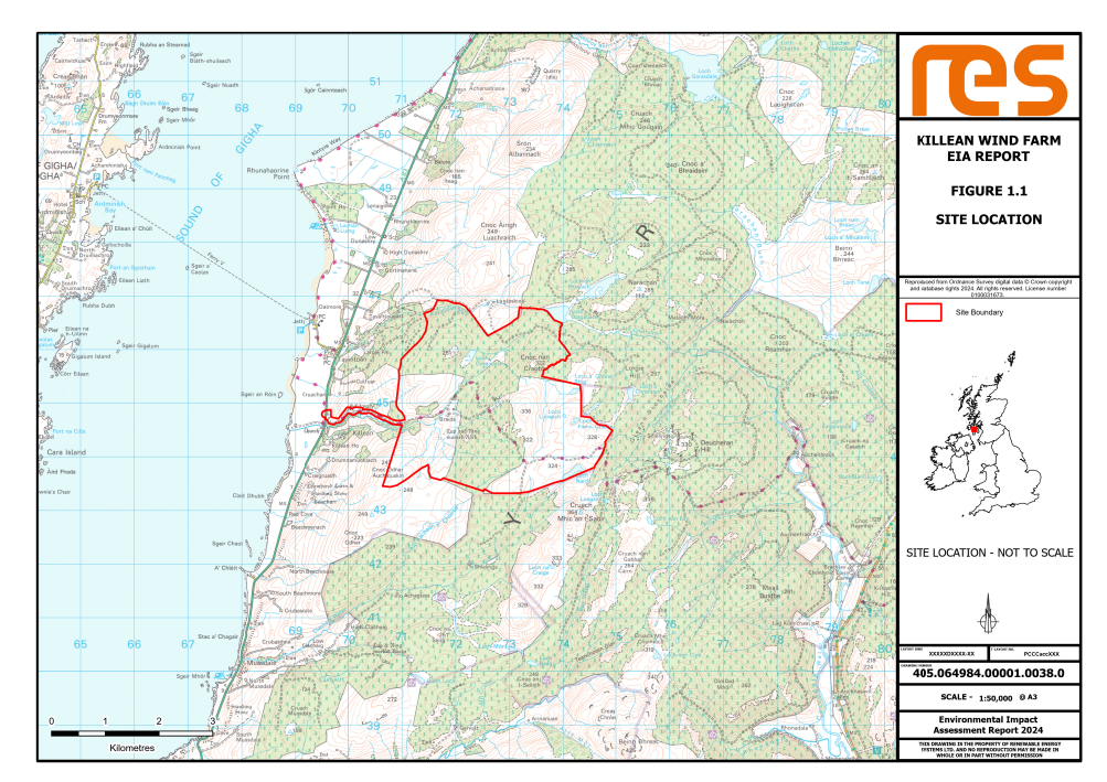
Site location
 Click to enlarge
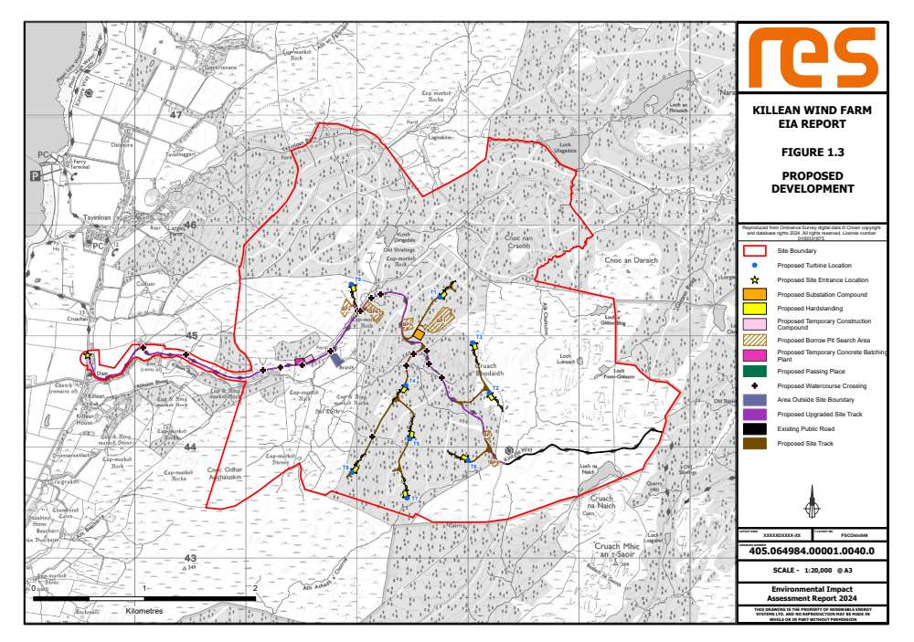
Proposed development
Click to enlarge
Planning application and documentation
Planning and Energy Policy Statement - Examines the national and local planning policy context for the Killean Wind Farm proposal, and the balance which needs to be struck between the need for wind energy development and the effect of the proposed development on the local environment. It also takes account of the benefits which could arise from the construction and operation of the development.
Pre-Application Consultation (PAC) Report - Explains how and when the community was consulted before the planning application for Killean Wind Farm was submitted to Scottish Ministers and how RES has responded to feedback from the community regarding the proposal.
Design Statement - Sets out the detailed design process which has led to the final layout of the proposed development.
Environmental Impact Assessment Report (EIAR)
Volume 1: Chapters
Reports on the Environmental Impact Assessment (EIA) work undertaken and examines the potential effects of the wind farm.
- Chapter 1. Introduction
- Chapter 2. Proposed Development Description
- Chapter 3. Design Evolution and Alternatives
- Chapter 4. Approach to EIA, Climate Change, Energy and Planning Policy
- Chapter 5. Landscape and Visual Impact Assessment
- Chapter 6. Cultural Heritage Assessment
- Chapter 7. Ecology
- Chapter 8. Ornithology
- Chapter 9. Geology, Hydrology and Hydrogeological Assessment
- Chapter 10. Traffic and Transport
- Chapter 11. Noise
- Chapter 12. Aviation, Radar and Defence
- Chapter 13. Other Issues
- Chapter 14. Schedule of Mitigation
- Chapter 15. Summary of Residual and Cumulative Effects
Volume 2a: EIAR Figures
Contains the figures (maps and drawings) associated with the EIA, except for the LVIA chapter.
- Figure 1.1 Site Location
- Figure 1.2 Application Boundary
- Figure 1.3 Proposed Development
- Figure 2.1 Typical Wind Turbine Elevation
- Figure 2.2a Typical Turbine Gravity Foundation
- Figure 2.2b Typical Turbine Piled Foundation
- Figure 2.3 Typical Crane Hardstand
- Figure 2.4a Typical Access Track
- Figure 2.4b Typical Access Track Widening Detail
- Figure 2.5a Typical Drainage Details
- Figure 2.5b Typical Drainage Details
- Figure 2.5c Typical Drainage Details
- Figure 2.5d Typical Drainage Details
- Figure 2.6 Typical Watercourse Crossing
- Figure 2.7 Indicative Site Entrance Layout
- Figure 2.8 Typical Cable Trench Details
- Figure 2.9a-b Typical Substation Compound Layout and Elevation
- Figure 2.10 Typical Telecommunications Mast
- Figure 2.11a-f Indicative Borrow Pit General Arrangement (BP1-6)
- Figure 2.12 Typical Batching Plant Layout
- Figure 2.13 Typical Temporary Construction Compound
- Figure 3.1 Site Layout Design Evolution
- Figure 6.1 Cultural Heritage: Inner Study Area
- Figure 6.2 Cultural Heritage: Outer Study Area
- Figure 6.3 Cultural Heritage: Cumulative Schemes
- Figure 7.1 International Designations Within 20km
- Figure 7.2 National Designations Within 5km
- Figure 7.3 Phase 1 Habitat Survey Map
- Figure 7.4 NVC Habitat Survey Map
- Figure 7.5 GWDTE Habitat Survey Map
- Figure 8.1 Ornithology Survey Areas (core)
- Figure 8.2 Black Grouse Leks and other records
- Figure 8.3 White tailed eagle flight lines
- Figure 8.4 Other scarce raptor flight lines
- Figure 8.5 Greenland White Fronted Goose flight lines
- Figure 8.6 Greenland White Fronted Goose feeding distribution
- Figure 8.7 Other waterfowl flight lines
- Figure 8.8 Golden Plover flight lines
- Figure 9.1 Local Hydrology
- Figure 9.2 Soils
- Figure 9.3 Superficial Geology
- Figure 9.4 Peatland Classification
- Figure 9.5 Bedrock Geology
- Figure 9.6 Regional Hydrogeology
- Figure 9.7 Groundwater Vulnerability
- Figure 9.8 GWDTE
- Figure 10.1 Traffic and Transport Study Area
- Figure 10.2 Traffic Count Locations
- Figure 11.1 Predicted Sound Footprint
- Figure 12.1 Killean Aviation Lighting Scheme
- Figure 13.1 Shadow Flicker Assessment
Volume 2b: LVIA Figures
Contains the wirelines and photomontage visualisations, produced to NatureScot specifications, which help to give an impression of how the proposal may look from a number of agreed viewpoints within the area.
- Figure 5.1 Site Location and Initial LVIA Study Area 35 km
- Figure 5.2 Site Location and Detailed LVIA Study Area 20 km
- Figure 5.3 Blade Tip ZTV to 35 km with Viewpoints
- Figure 5.4 Blade Tip ZTV to 20 km with Viewpoints
- Figure 5.5 Hub Height ZTV to 35 km with Viewpoints
- Figure 5.6 Hub Height ZTV to 20 km with Viewpoints
- Figure 5.7 Lit Turbine ZTV to 20 km with Viewpoints
- Figure 5.8 Turbine Lighting Intensity ZTV to 20 km with Viewpoints
- Figure 5.9 Landscape Designations within 35 km
- Figure 5.10 Landscape Designations within 20 km
- Figure 5.11 Landscape Designations to 20 km with Blade Tip ZTV and Viewpoints
- Figure 5.12 Landscape Character Types within 35 km
- Figure 5.13 Landscape Character Types within 20 km
- Figure 5.14 Landscape Character Types within 20 km with Blade Tip ZTV and
- Figure 5.15 Topography Plan to 35 km
- Figure 5.16 Local Landscape Context to 5 km
- Figure 5.17 Principal Visual Receptors to 35 km
- Figure 5.18 Principal Visual Receptors to 20 km Blade Tip ZTV and Viewpoints
- Figure 5.19 Blade Tip ZTV to 35 km (NW Quadrant) with Viewpoints
- Figure 5.20 Blade Tip ZTV to 35 km (SW Quadrant) with Viewpoints
- Figure 5.21 Blade Tip ZTV to 35 km (NE Quadrant) with Viewpoints
- Figure 5.22 Blade Tip ZTV to 35 km (SE Quadrant) with Viewpoints
- Figure 5.23 Hub Height ZTV to 35 km (NW Quadrant) and Viewpoints
- Figure 5.24 Hub Height ZTV to 35 km (SW Quadrant) and Viewpoints
- Figure 5.25 Hub Height ZTV to 35 km (NE Quadrant) and Viewpoints
- Figure 5.26 Hub Height ZTV to 35 km (SE Quadrants) and Viewpoints
- Figure 5.27 Other Wind Farms within 20 km
- Figure 5.28 Cumulative ZTV with operational Deucharan Hill and Cour
- Figure 5.29 Cumulative ZTV with operational Gigha and Gigha Extension
- Figure 5.30 Cumulative ZTV with operational Blary Hill, Auchadadiue, Beinn an Tuirc, Beinn an Tuirc Extension and Beinn an Tuirc Phase 3
- Figure 5.31 Cumulative ZTV with operational Freasdail
- Figure 5.32 Cumulative ZTV with operational Tangy and Tangy Extension
- Figure 5.33 Cumulative ZTV with consented High Constellation and Eascairt
- Figure 5.34 Cumulative ZTV with consented Tangy Repowering
- Figure 5.35 Cumulative ZTV with consented Airigh
- Figure 5.36 Cumulative ZTV with in planning Clachaig Glen
- Figure 5.37 Viewpoint 1 – Loch na Naich
- Figure 5.38 Viewpoint 2 – Killean
- Figure 5.39 Viewpoint 3 – Tayinloan Jetty
- Figure 5.40 Viewpoint 4 – Point Sands
- Figure 5.41 Viewpoint 5 – Beinn Bhreac
- Figure 5.42 Viewpoint 6 – Ardminish Bay Jetty (Gigha)
- Figure 5.43 Viewpoint 7 – Glenbarr War Memorial
- Figure 5.44 Viewpoint 8 – Creah Bhan
- Figure 5.45 Viewpoint 9 – A83 at Clachan
- Figure 5.46 Viewpoint 10 – Beinn Bharrain, Isle of Arran
- Figure 5.47 Viewpoint 11 – B8024, Knapdale
- Figure 5.48 Viewpoint 12 – Islay Ferry, West Loch Tarbert
- Figure 5.49 Viewpoint 13 – High Lossit, south of Machrihanish
- Figure 5.50 Viewpoint 14 – Craighouse, Jura
- Figure 5.51 Viewpoint 15 – Maolbhuie Cottages, near Ardbeg Distillery
- Figure 5.52 Viewpoint 16 - Pirnmill
- Figure 5.53 Viewpoint 17 – Machrie Bay
Volume 3: Technical Appendices
Contains the data supporting the findings of the Environmental Impact Assessment Report.
- Technical Appendix 2.1 Outline Construction and Environmental Management Plan
- Technical Appendix 2.2 Outline Borrow Pit Management Plan
- Technical Appendix 2.3 Forestry Report
- TA Figure 2.3.1 Forestry Study Area
- TA Figure 2.3.2 Age Class Distribution
- TA Figure 2.3.3 Baseline Species Comp
- TA Figure 2.3.4 Baseline Fell Phase
- TA Figure 2.3.5 Baseline Restock Speci Comp
- TA Figure 2.3.6 Wind Farm InfrasFelling
- TA Figure 2.3.7 Wind Farm Fell Phases
- TA Figure 2.3.8 WF Restock Spec Comp
- Technical Appendix 5.1 Assessment Criteria
- Technical Appendix 5.2 ZTV and Visualisation Information
- Technical Appendix 5.3 Preliminary Assessment of LCTs & Designations
- Technical Appendix 5.4 Preliminary Assessment of Visual Receptors
- Technical Appendix 5.5 Viewpoint Assessment
- Technical Appendix 5.6 Residential Visual Amenity Assessment
- Technical Appendix 5.7 Assessment of Night-time Lighting
- Technical Appendix 5.8 Effects on North Arran NSA Special Landscape Qualities
- Technical Appendix 5.9 Wirelines from Ferry Routes
- Technical Appendix 6.1 Cultural Heritage Assets within the Inner Study Area
- Technical Appendix 6.2 Cultural Heritage Assets within the Outer Study Area
- Technical Appendix 6.3 Cultural Heritage Visualisations (Figures 6.4 to 6.12):
- TA Figure 6.4 St John’s Church (SM3030) & Killean Estate Buildings including Dolls Houses (LB43266)
- TA Figure 6.5 Cultural Heritage Visualisation: Braids cup and ring marked stone (3501) and hut circle (3942)
- TA Figure 6.6 Cultural Heritage Visualisation: Lagloskine cup marked stone (3473)
- TA Figure 6.7 Cultural Heritage Visualisation: Drumnamucklach cup and ring marked stone (3178)
- TA Figure 6.8 Cultural Heritage Visualisation: Loch Dirigadale shielings (asset 6) and cup-marked rock (3470)
- TA Figure 6.9 Cultural Heritage Visualisation: Killean House (LB12005)
- TA Figure 6.10 Cultural Heritage Visualisation: Killean Fort (SM3179)
- TA Figure 6.11 Cultural Heritage Visualisation: Achamore House (LB11449)
- TA Figure 6.12 Cultural Heritage Visualisation: Low Clachaig cup marked boulder (SM4352)
- Technical Appendix 7.1 Phase 1 and NVC Habitat Surveys 2023
- Technical Appendix 7.2 Bat Baseline Survey Report 2022 and 2023
- Technical Appendix 7.4 Fish Habitat Survey Report
- Technical Appendix 7.5 Species Protection Plan
- Technical Appendix 7.6 Outline Biodiversity Enhancement Management Plan
- Technical Appendix 8.1 Breeding Bird Survey Report 2022
- Technical Appendix 8.2 Breeding Bird Survey Report 2023
- Technical Appendix 8.3 Wintering Bird Survey Report 2021-22
- Technical Appendix 8.4 Wintering Bird Survey Report 2022-23
- Technical Appendix 8.5 Collision Risk Modelling Calculations Report
- Technical Appendix 8.6 Breeding Bird Protection Plan
- Technical Appendix 8.7 Habitats Regulations Appraisal (HRA) Report
- Technical Appendix 9.1 Peat Landslide Hazard Risk Assessment (PLHRA)
- Technical Appendix 9.2 Peat Management Plan (PMP)
- Technical Appendix 9.3 Schedule of Watercourse Crossings
- Technical Appendix 9.4 Private Water Supply Risk Assessment (PWSRA)
- Technical Appendix 10.1 Abnormal Loads Route Assessment
- Technical Appendix 10.1 Abnormal Loads Route Assessment Annex A SPAs
- Technical Appendix 11.1 Issues Scoped Out of Wind Farm Noise Assessment
- Technical Appendix 11.2 Calculating Standardised Wind Speed
- Technical Appendix 11.3 Background Sound Survey Photos
- Technical Appendix 11.4 Instrumentation Records
- Technical Appendix 11.5 Noise Charts
- Technical Appendix 11.6 Suggested Planning Conditions
- Technical Appendix 12.1 Correspondence from the CAA
- Technical Appendix 12.2 Proposed Draft Condition to secure a reduced visible lighting scheme for the Proposed Development
- Technical Appendix 13.1 Socio-economic Assessment
- Technical Appendix 13.2 Carbon Calculator Core Input Data
- Technical Appendix 13.3 Carbon Payback and CO2 Emissions
Volume 4: Non-Technical Summary (NTS)
Contains an overview, in non-technical language, of the main findings of the EIA Report.